Paper on Global Positioning System
ABSTRACT
The ability to locate oneself on the earth and in its vicinity and navigate over its surface is knowledge that has fascinated humankind for these millennia. All the techniques available that implement the above mentioned core theme use, “GLOBAL POSITIONING SYSTEM” (GPS), which has become a vital global utility, indispensable for modern navigation on land, sea, and air around the world, as well as an important tool for Map-Making and Land Surveying.
This paper provides description of all the technical aspects of GPS along with techniques to improve the accuracy of the system. It also deals with some of very important GPS applications like vehicle tracking, mobile tracking, in agriculture, in geology etc towards the end.
Index Terms
Doppler distortion, Ephemeris errors, Navigation signal, Line of sight, Navigation message, y-code, Almanac, Jamming.
INTRODUCTION
GPS is a space-based radio positioning system that provides 24*7 three-dimensional positions, velocity and time information to suitably equipped users anywhere on or near the surface of the earth and sometimes off the earth.
It consists of a network of twenty four orbiting satellites that are orbiting in space eleven thousand miles from earth and a GPS receiver includes an antenna adapted to receive GPS satellite signals from each of the GPS satellites. There is navigation solution determining circuitry coupled to the antenna that receives the GPS satellite signals and performs navigation and fault detection and exclusion functions. The GPS satellites are orbited high enough to avoid problems associated with land based systems, yet can provide accurate positioning twenty four hours a day, anywhere in the world.
HOW DOES GPS WORK?
GPS Constellation:
There are at least twenty four operational GPS satellites at all times which orbit with a time period of twelve hours. Ground stations are used to precisely track each satellite's orbit. Each GPS satellite transmits data that indicates its location and the current time. All GPS satellites synchronize operations so that these repeating signals are transmitted at the same instant. The receiver calculates position of the satellites in three dimensions if the distance to at least four GPS satellites is known.
The following figure shows the GPS constellation with all the 24 satellites revolving in their respective orbits.

Satellites:
As of august 2006 the GPS system used a satellite constellation of 24 active Block -M satellites for the global coverage in intermediate circular orbits. There are three spare satellites in orbit, in case of any failure. Each satellite circles the earth twice each day at an altitude of 20,200 kilometers. The orbits are aligned so that at least four satellites are always within line of sight from almost any place on earth.
The flight paths of the satellites are measured by five monitor stations around the world which are Hawaii, Kwajalein, Ascension Island, Diego Garcia, Colorado Springs and the master control station, at Schriever Air Force Base.
The Frequencies Used:
The frequencies that make up the GPS electromagnetic spectrum are L1 (1575.42 MHz), L2 (1227.60 MHz), L3 (1381.05 MHz) with two new signals L4 (1841.40 MHz), L5 (1176.45 MHz) also being studied.
Receivers:
GPS receivers vary widely in accuracy because of the expense of adding more radio receivers needed to tune in more satellites. More expensive units, known as "dual-frequency receivers", tune in the L2 signals in order to correct for ionospheric delays.
Another major factor in the accuracy of a GPS fix is the amount of processing applied to the received signals. GPS receivers may include an input for differential corrections, using the RTCM SC-104 format. Receivers with internal DGPS receivers can outperform those using external RTCM data. Many GPS receivers can relay position data to a PC or other device using the NMEA 0183 protocol. Receivers can interface with external devices via a number of means, such as a serial connection, a USB connection or even a wireless connection like the BLUETOOTH technology.
Navigation Signals:
GPS satellites transmit signals to equipment on the ground. GPS receivers passively receive satellite signals but do not transmit. GPS receivers require an unobstructed view of the sky, so they are used only outdoors and they often do not perform well within forested areas or near tall buildings.
GPS satellites broadcast three different types of data in the primary navigation signals. The first is the almanac which sends coarse time information with second precision along with status information about the satellites.
The second is the ephemeris, which contains orbital information that allows the receiver to calculate the position of the satellite at any point in time. These bits of data are folded into the 37,500 bit Navigation Message.
The satellites also broadcast two forms of accurate clock information, the Coarse Acquisition code and the precise code. In normal operation, the so-called "anti-spoofing mode", the P code is first encrypted into the Y-code.
The following figure gives an overview of how the GPS works. It includes the spacecraft constellation, master control system and the signal structure
Calculating Positions:
In a nutshell, GPS is based on satellite ranging - calculating the distances between the receiver and the position of satellites. The receivers measure the time delay between when the signal is sent and the local time when the signal is received. This delay, multiplied by the speed of light, gives the distance to that satellite.
The receiver now has an accurate estimate of the position and the distance of the satellite. This tells the receiver that it lies on the surface of an imaginary sphere whose radius is that distance. To calculate the precise position, at least four such measurements are taken simultaneously. This places the receiver at the intersection of the four imaginary spheres as shown in the figure below
.
Accuracy:.
The accuracy of position calculated by a GPS receiver relies on three accurate measurements: the current time, the position of the satellite, and the time delay for the signal. However, several "real world" effects intrude and degrade the accuracy of the system as shown in the table.
Source Effect
Ionospheric effects ± 5 meterEphemeris errors ± 2.5 meter
Satellite clock errors ± 2 meter
Multipath distortion ± 1 meter
Tropospheric effects ± 0.5 meter
Numerical errors ± 1 meter or less
Techniques to Improve Accuracy:
There are various methods available which improve the accuracy to a great extent.
Differential GPS used by receivers which can improve the normal GPS accuracy of 4-20 meters to 1-3 meters.
Wide Area Augmentation System is used in case of ionospheric delays. This system uses a series of ground reference stations to calculate GPS correction messages, which are uploaded to a series of additional satellites in geosynchronous orbit.
A Local Area Augmentation System is similar to WAAS but in this case, the correction data are transmitted from a local source, typically at an airport or another location where accurate positioning is needed. These correction data are typically useful for only about a thirty to fifty kilometer radius around the transmitter.
A Carrier-Phase Enhancement utilizes the 1.575 GHz L1 carrier wave to act as a sort of additional clock signal, resolving ambiguity caused by variations in the location of the pulse transition (logic 1-0 or 0-1) of the C/A signal.
Wide Area GPS Enhancement which provides more accurate satellite clock and ephemeris data to specially-equipped receivers.
GPS APPLICATIONS
GPS can provide any point on earth with a unique address and hence finds its greatest utility in the field of Geographic Information Systems (GIS). However GPS is not just confined to GIS but is widely being used in many other areas as well.
GPS for GIS:
After GPS determines a location on the surface of the earth, we shall know what is at that location. The word "what" is the object or objects which will be mapped referred to as "Features", and are used to build a GIS. It is the power of GPS to precisely locate these Features which adds so much to the utility of the GIS system.
There are three types of Feature which can be mapped: Points, Lines and Areas which correspond to a single GPS coordinate position, a collection of GPS positions and those with lines tied to each other to form a closed area respectively.
Additional information such as color, size, cost, occupants, etc are provided which are used to sort and classify a feature and are known as Attributes.
A Feature List is a database which contains a listing of the Features which will be mapped, as well as the associated Attributes for each Feature. When a Feature List is used in the field, the first step is to select the Feature to be mapped. Once a Feature is selected, the Attributes for that Feature are automatically listed.
The final step in incorporating GPS data with a GIS system is to export the GPS and Feature data into the GIS system. During this process, a GIS "layer" is created for each Feature in the GPS job.
Earthquake Detection:
The satellites in the constellation are arranged so that several of them are "visible" from any point on the surface of the earth at any time. The GPS network will continuously measure movements of the earth's crust with a precision of one millimeter per year, which will show us where strain is building up and the receivers that will continuously measure the constant, yet physically imperceptible, movements of earthquake faults. Scientists face lot of difficulty to rapidly assess the size of large earthquakes but, GPS-based detection offers the most advantages even when an earthquake has a magnitude of 8.5.
Not only earthquakes but, scientists can now estimate an earthquake’s potential for causing a tsunami using deep ocean buoy readings and seismometer data.
A new tsunami-detection technique that uses GPS data could potentially save many lives by helping alert people in time to escape.
Precise Time Reference:
Many systems that must be accurately synchronized use GPS as a source of accurate time. For instance, the GPS can be used as a reference clock for time code generators or NTP clocks. The atomic clocks on the satellites are set to "GPS time". GPS time is counted in days, hours, minutes, and seconds, in the manner that is conventional for most time standards. Communications networks often rely on this precise timing to synchronize RF generating equipment, network equipment, and multiplexers.
Military:
GPS allows accurate targeting of various military weapons including cruise missiles and precision-guided munitions, as well as improved command and control of forces through improved location awareness. The satellites also carry nuclear detonation detectors, which form a major portion of the United States Nuclear Detonation Detection System. Most effective use of GPS in military can be seen in jamming of any radio navigation system.
Agriculture:
GPS is used for the guidance of tractors and other large agricultural machines via auto steer or a visual aid displayed on a screen, which is extremely useful for controlled traffic and row crop operations and when spraying.
Further its applications include precision agriculture, site-specific farming and prescription farming. GPS applications in farming include guidance of equipment such as sprayers, fertilizer applicators and tillage implements to reduce excess overlap and skips. They can also be used to precisely locate soil-sampling sites, map weed, disease and insect infestations in fields and apply variable rate crop inputs, and, in conjunction with yield monitors, record crop yields in field
Surveying:
More costly and precise receivers are used by land surveyors to locate boundaries, structures, and survey markers, and for road construction. There is also a growing demand for Automatic Grade Control systems that use GPS positions and 3D site plans to automatically control the blades and buckets of construction equipment.
Navigation:
GPS is used by people around the world as a navigation aid in cars, airplanes, and ships. Hand-held GPS receivers can be used by mountain climbers and hikers. Glider pilots use the logged signal to verify their arrival at turn points in competitions.
Vehicle Tracking:
A GPS tracking system uses GPS to determine the location of a vehicle, person, or pet and to record the position at regular intervals in order to create a track file or log of activities. The recorded data can be stored within the tracking unit, or it may be transmitted to a central location, or Internet-connected computer, using a cellular modem,
2-way radio or satellite. This allows the data to be reported in real-time; using either web browser based tools or customized software.

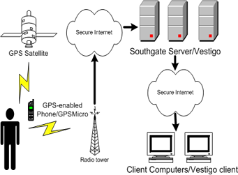
Mobile Phone Tracking:
This is ideal for business especially if its mobile, what you need is mobile phone tracking which is simple and easy to use and can be set up in minutes. Unlike vehicle tracking, mobile tracking also means one can continue to track, even when the employee has left their car or van. This allows you to monitor the work force every minute, any time, day or night to improve business efficiency.
Interestingly, mobile phone tracking can be extended to track where a person is, by triangulating his position between cells, track which cell he is entering by knowing the cell from which he enters.
GPS is a great system to use, especially with the event of GPS receivers becoming smaller and smaller and better GPS software coming out and providing more accurate tracking for the user who needs to track more frequently. The following suggest a clear description of the whole process of tracking that takes place.
Geophysics and Geology:
High precision measurements of earth’s crustal strain can be made with GPS by finding the relative displacement between GPS sites, one of which is assumed to be stationary. Multiple stations situated around an actively deforming area (such as a volcano or fault zone) can be used to find strain and site velocities relative to a stable reference site. For example, measurements of ground deformation around a volcano can be used to interpret the source and cause—a dike, sill, or other body beneath the surface.
Entertainment:
The availability and cost of hand-held GPS receivers has led to recreational applications including location-based games like the popular game Geocaching.
CONCLUSION
GPS is the product of a long and complicated history and has brought many changes in the society since then. It has increasingly become more evident in society through its implementation into items such as vehicles, mobile phones and pet collars. The economics of GPS make the measurement technology readily available and accessible to all users. Many issues surround GPS when it comes to its future. The most certain aspect of the future of GPS is its increased usage and its expansion into new areas of application.
We have seen that GPS setup could be just the one we may need for the PDA devices which are considered to be using the latest technology as on today. Thus, what one can conclude is that GPS will continue to intrude into many other fields and will be an evergreen technology for many more years to come.
REFERENCES
- The Global Positioning System: Challenges in GPS - Article by Kanwar Chadha.
- Global Positioning System Overview by Peter H. Dana.
- GPS Satellite Surveying, by Wiley & Sons.


0 comments:
Post a Comment